Cape Elizabeth, Maine
Real Estate & Community Information
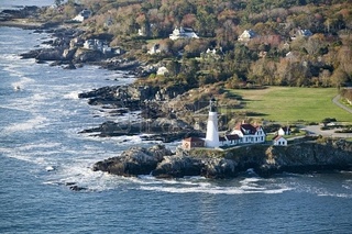
Cape Elizabeth’s Portland Headlight is one of the most photographed lighthouses in the world. It is also widely believed that Henry Wadsworth Longfellow wrote many lines of his poems while sitting at his favorite spot near the base of its tower. However, those who only visit the lighthouse are missing out on the rich history of the area and some of the best scenery in central Maine. Located less than 4 miles from the City of Portland, Cape Elizabeth is home to the 94-acre Fort Williams Park, where Portland Head Light is located. In addition to the lighthouse, which is Maine’s oldest, the park contains ruins of the old fort, which housed troops in World Wars I and II.
Two Lights State Park offers unobstructed views of Casco Bay and a view of the two lighthouses from which the park got its name. One of these towers was the subject of Edward Hooper's famous painting, “Lighthouse at Two Lights.” Crescent Beach State Park attracts sunbathers as well as fisherman and water sports enthusiasts. It is a popular spot for families because the crescent shape of the mile-long beach keeps big waves at bay.
Two Lights State Park offers unobstructed views of Casco Bay and a view of the two lighthouses from which the park got its name. One of these towers was the subject of Edward Hooper's famous painting, “Lighthouse at Two Lights.” Crescent Beach State Park attracts sunbathers as well as fisherman and water sports enthusiasts. It is a popular spot for families because the crescent shape of the mile-long beach keeps big waves at bay.
Extending 12 miles into open ocean, rimmed by craggy shores and sandy beaches, Cape Elizabeth marks the entrance to spectacular Casco Bay. Most of the town's residential and commercial activity lies close to the bay's edge. The size of the community is 9,337 acres, or 15 square miles. 2000 census figures put the town's population at 9,068, with a population density of approximately 550 residents per square mile.
History
As early as 1529, Cape Elizabeth appears as a nameless headland mapped by a Spanish cartographer.
Seventy-five years later, Samuel de Champlain charted the promontory, but not until 1604, following exploration by John Smith, was the land given its name in honor of Princess Elizabeth, sister of Charles I of England.
Events of the years that followed make an intriguing story: the 1632 establishment of Richmond's Island as a fishing and trading post, the struggles of settlers in small isolated groups as they began fishing and farming, conflicts between immigrants and the region's Native Americans, occasional pirating from the seas, the Revolutionary War...These and other events marked the first 200 years of colonial history in the region.
Originally a part of Portland (named Falmouth at the time), the citizens petitioned for and obtained their own government in 1765, thus including all the area lying south of Portland Harbor and east of the Spurwink River. Commercial and industrial growth in the north end of the town, nearest the harbor (now South Portland), was in sharp contrast to the continuing rural character of the southern tip of the Cape. In 1895, the two sections agreed to separate, and from that date forward the southern end of the original town became the present town of Cape Elizabeth.
The 20th century history of the community has been one of gradual residential growth. The majority of inhabitants now work in the Greater Portland area, and only very few of the working farms still exist. As the town embarks on the 21st century, townspeople recognize the importance of their farming and fishing heritage, and have taken legislative measures to protect and encourage Cape Elizabeth's rural character.